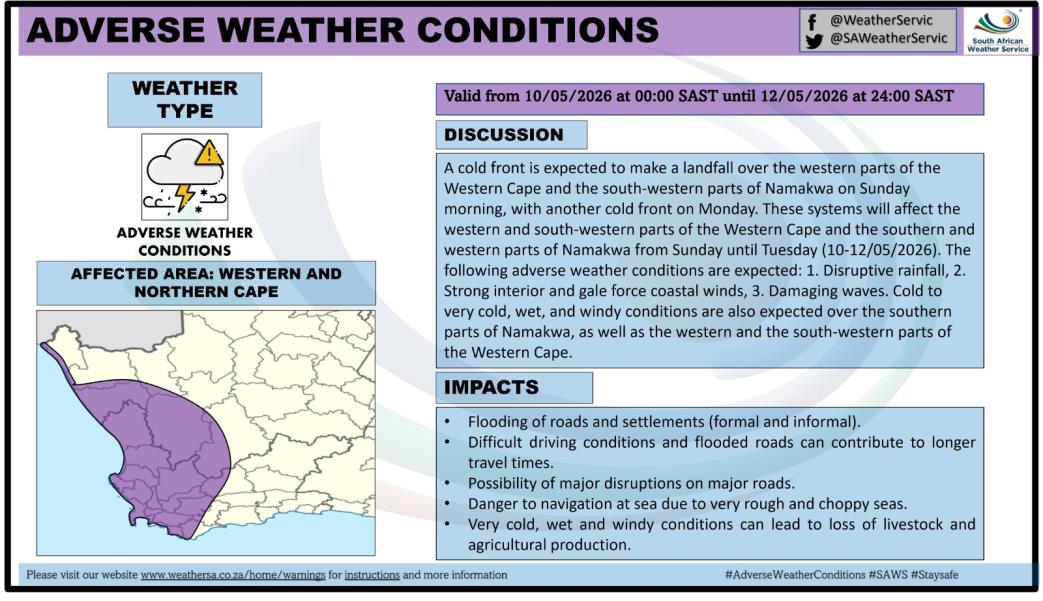
According to SAWS, a strong cold front is expected to make landfall over the Western Cape on Sunday afternoon before moving eastwards along the southern parts of the country. The system follows closely after a prolonged period of adverse weather caused by a cut-off low weather system.
The weather system is expected to bring widespread disruptive rainfall, strong to gale-force winds, very rough seas, and significantly colder temperatures over the western interior and coastal regions.
Expected Weather Conditions
Disruptive rain is expected over the western parts of the Western Cape from Sunday evening into Tuesday. Current indications suggest a low likelihood of severe flooding, particularly over:
-City of Cape Town
-Cape Winelands
-Overberg
Rainfall accumulations between 100 and 200 millimetres are possible in some areas. This may lead to significant impacts on infrastructure, transport routes, and vulnerable communities.
Very cold and windy conditions are also expected across the western interior of South Africa, with wind speeds ranging between 50 and 70 km/h.
Strong to gale-force winds are expected along the west and south coast from Sunday afternoon, continuing until at least Tuesday night.
There is also a high risk of very rough and choppy sea conditions with destructive waves, posing dangers to navigation at sea and coastal activities.
Weather Warnings Issued
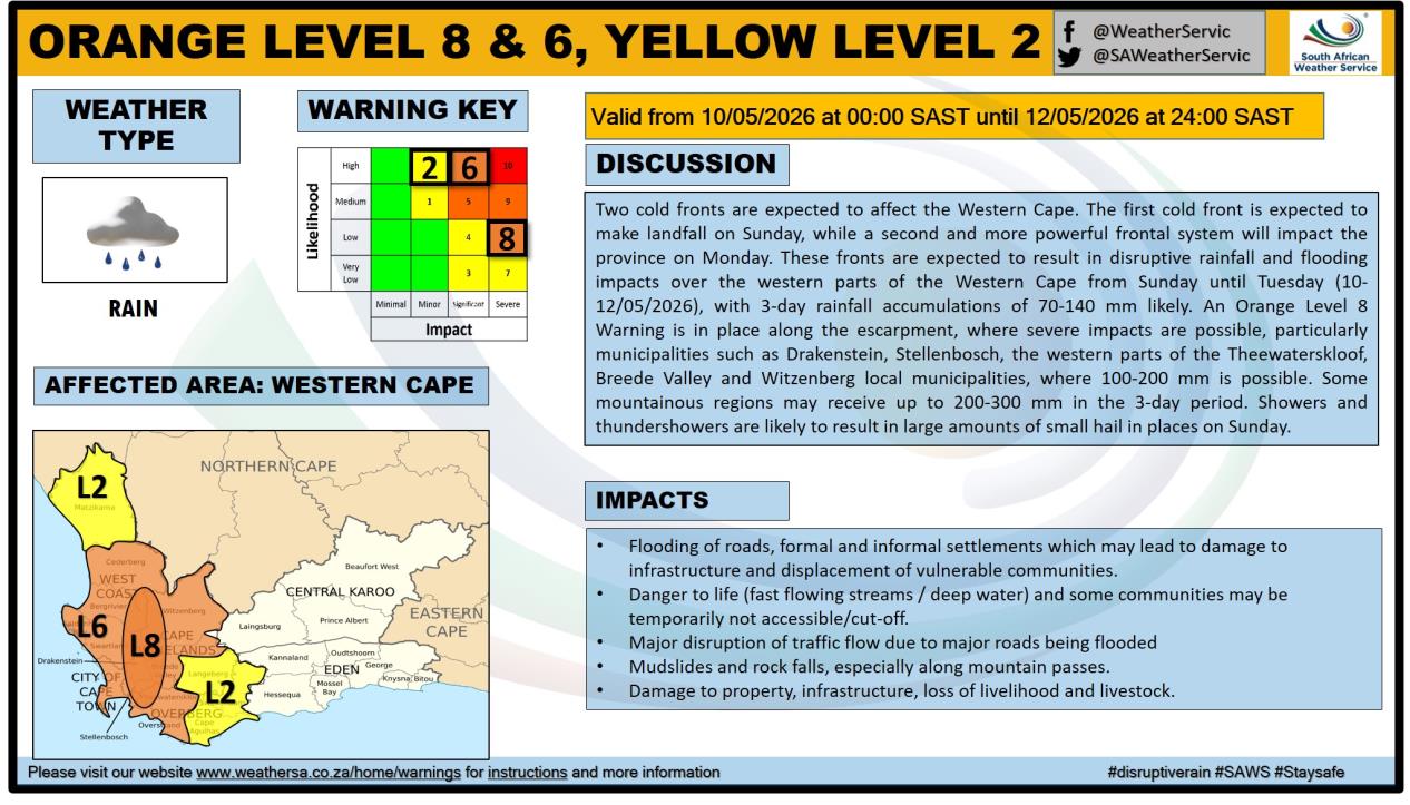
Orange Level 8 Warning
Disruptive rainfall leading to flooding of roads, bridges, formal and informal settlements, mudslides, and danger to life due to fast-flowing rivers is expected over mountainous regions of:
-Drakenstein
-Stellenbosch
-Western parts of Theewaterskloof
-Breede Valley
-Witzenberg local municipalities
The warning is valid from Sunday to Tuesday.
Orange Level 6 Warning – Rainfall
Flooding of roads, low-lying bridges, and settlements is expected over:
-West Coast
-Cape Winelands
-City of Cape Town
-Western parts of the Overberg District
Orange Level 6 Warning – Winds and Waves
Damaging winds and waves are expected along the coast between Lambert's Bay and Plettenberg Bay from Sunday to Tuesday.
Orange Level 5 Warning
Damaging interior winds could result in:
-Damage to formal and informal settlements
-Power interruptions
-Closure of routes due to falling trees
The warning applies to parts of the Cape Winelands and western parts of the Central Karoo District.
Yellow Level 4 Warning
Damaging winds and waves are expected along the coast between Alexander Bay and Lambert's Bay.
Yellow Level 2 Warning – Winds
Localised damage to informal settlements, falling trees, and problems for high-sided vehicles are expected over:
-West Coast
-City of Cape Town
-Overberg
-Central Karoo
-Kannaland Municipality
-Southern Namakwa District
Yellow Level 2 Warning – Snowfall
Disruptive snowfall is expected over the Karoo Hoogland Municipality in the Northern Cape and parts of the Cape Winelands District.
Possible impacts include:
-Loss of vulnerable livestock
-Icy roads
-Closure of mountain passes
Public Safety Advice
The public is urged to:
-Monitor official weather updates and warnings
-Avoid unnecessary travel during heavy rain and flooding
-Never attempt to cross flooded roads, bridges, or rivers
-Secure loose outdoor objects
-Avoid coastal and sea activities during the warning period
-Provide adequate shelter for livestock and pets
-Prepare emergency kits with essentials such as flashlights, batteries, blankets, and warm clothing
-Community leaders and disaster management authorities have also been encouraged to remain on high alert and activate contingency plans where necessary.
-SAWS said warnings will be updated as the likelihood and severity of impacts become clearer. The public has also been advised not to share unverified weather information.